Orange Bus Line: Los Angeles, California
One of the many odd things about LA is the abundance of wide abandoned railroad right of ways, often even leaving track in (more on that later). But on rare occasions, they actually do something with it. Here we have a abandoned right of way converted to a BRT. BRT stands for Bus Rapid Transit. There's none of it in SimCity, but basically imagine a road that's only for buses. You can clearly see that it says for cars to keep clear of that intersection (much like railroad tracks). I was a bit disappointed though in the fact that it still looks like the buses may have to stop. Heck, if I were a BRT planner, buses would only stop at stations. Mandatory red lights for ALL at-grade intersections when a bus is coming through! They ain't stopping for NOBODY!


Also, did some digging, this was the Burbank Branch, abandoned in 1991.
Manchester Road: Des Peres, Missouri
Here we have an intersection found just about everywhere where there's Interstate or Interstate-like highways: a crossing road, two exits (sometimes may be connected to a frontage roads), exit highway, turn left, turn right, go straight, get on highway: very straight-forward. But around 2001 or so, this intersection did a dramatic rebuilding. First off, interestingly enough, the mall just to the east of this did a rebuild by demolishing the old mall and building a new one. The road, however, had several interesting adjustments. It split in two, building a new three-lane road to the north for westbound traffic, and reconfiguring the five lanes (two west, two east, turning lane) for a new traffic flow. See if you can figure this out.

290 Leftovers: Hockley, Texas
When US-290 bypassed the towns of Hempstead, Waller, and Hockley in the mid-to-late 1990s, it created some very odd "leftovers".
First up is the Bauer-Hockley/Grimes division. The abnormally sharp curve was created for these two rural roads when 290 bisected it, but what's strange is three factors.
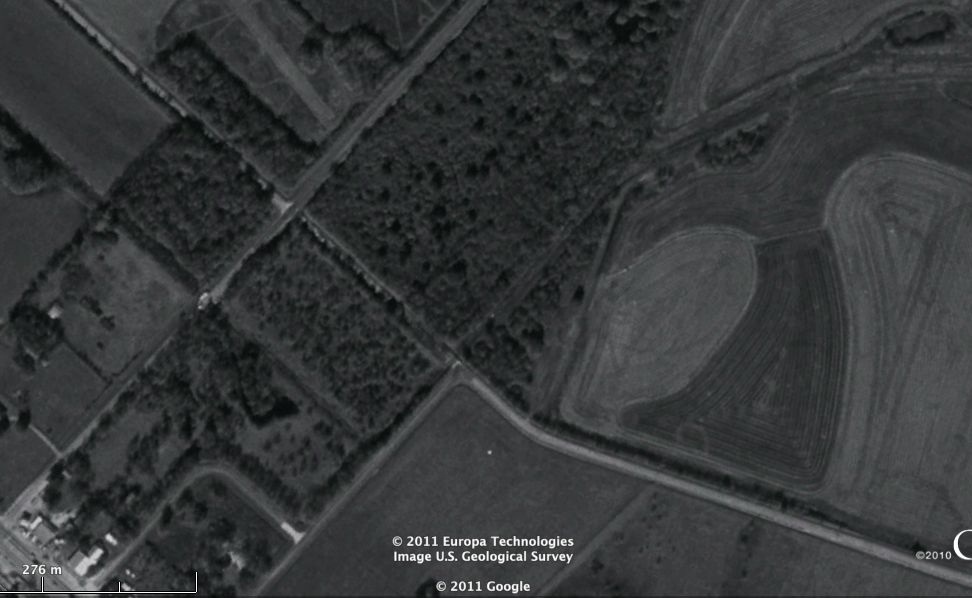

1. There's a wooden bridge on the road heading northwest. A wooden bridge. Awesome. It's rare for a public road nowadays.
2. The road was bisected during construction, so there's a Bauer-Hockley Road to the east which used to connect with the Bauer-Hockley Road to the west. But Bauer-Hockley extends southward (westward, with the wooden bridge, is Grimes). I should mention though that especially in Texas rural areas (and even today), it's not uncommon to turn right or left to stay on the same "road" traveling. Traveling south on nearby Katy Hockley Road has the same "features".
3. Possibly as a leftover of the intersection days, you stop if you're going to turn left on the curve, but not turning right. Guess that's safer.
There's also, in that same area, a little paved cul-de-sac that goes nowhere and has no driveways. Property lines suggest that it was originally to be served as the frontage road terminus (and possibly might have!), but it serves nothing of the sort today.
Both of these are endangered roads, because there's plans to build the Hempstead Tollway possibly to that point in the future (but I don't have a link).
Continuous flow intersection: Baton Rouge, Louisiana
A rare, relatively new intersection, so few that there are only 11 in the United States. Now, technically, the B.R. intersection, which I have personally driven through (not driven past, like Hempstead, or seen on GE only, like our first two examples).
The images from Google Earth are twisted 90°


However, the CFI in Baton Rouge is a bit different than a normal CFI on two conditions.
1. The CFI is only for the northbound and southbound lanes of the "bigger road", Airline Highway.
2. A frontage road was added for some businesses that used to plug directly into Airline (Airline is NOT limited-access)
I seem to remember that in 2008, it was a bit difficult to maneuver this one, we were heading back from a Christmas party as it were, our car was beating the other car home, but we got side-tracked and got in a less-advantegous lane (frontage or main, I don't remember), and allowed the other car to beat us home. All the while we were trying to avoid a lunatic that honked a split second after an intersection light turned green (but before cars could accelerate). Said lunatic also had a car with a bowling ball sized dent on top of the car.
The intersection was reconstructed in 2005 and opened in early 2006.
Katy Freeway: Houston, Texas
Katy Freeway is another awesome "rebuild". How do you take a congested freeway and transform it into one of the widest freeways in America, with 26 lanes, whether they be frontage roads, HOV, toll, etc.? Use what you've got!
You see, Katy Freeway (which leads out to Katy, Texas), paralleled the Katy railroad (the M-K-T, as it were). By 1996, the Katy Freeway was an overcrowded, dated mess that hadn't been updated in decades, while the Katy railroad was a dilapidated disaster waiting to happen. In 1997, another merger happened, and the tracks were dismantled.
This left a very wide right-of-way, plus, in some parts, a now-redundant frontage road that was used for accessing businesses. Several years later, the expansion began. Regrettably, I couldn't get a good shot of both the widest freeway part and the redundant lane part, and everything has changed so dramatically along the route it's hard to really get a feel for things anyway.
For example, the shot below does not have the "extra frontage road" and the buildings have changed. The building to the north was an IKEA (before they built a new one), and the building to the south was a hotel that has since been demolished.


While some homes and aforementioned hotel were demolished for the expansion, the majority of homes and businesses were saved.
I recommend scouting around the area on Google Earth and playing with the time slider.
No doubt all of these created agonizing construction zones and demolished roads. Even the BRT surely must have required something as the railroad was stripped, patched, and repaved.
But in SimCity, there is no construction zones. Want a better interchange? Simple: pause and demolish it. One minute it's there, next minute gone. Poof. There is no trace of railroads. Railroad needs to disappear? Click click! The roads are spotless.
No comments:
Post a Comment